Views
39
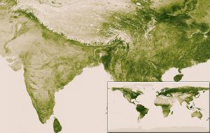
A new interactive map produced by NASA and the National Oceanic and Atmospheric Administration shows how much of the earth is covered in living plants. The researchers were able to gather a years worth of satellite images and compile them into a single high-resolution image that shows which parts of the planet are the lushest and which ones are covered by the sparsest vegetation. The darkest green areas are the lushest in vegetation, while the pale colors are sparse in vegetation cover either due to snow, drought, rock or urban areas. |
Subscribe to our newsletter and recieve a selection of our cool articles every week.

Copyrights @ 2025 All rights reserved by Pangea EcoNetAssets Pvt Ltd.