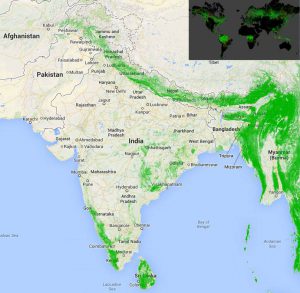
The interactive map by Google Earth

graph-icon

Views

111

Google Earth

Google Earth recently launched the first high-resolution map of global deforestation. It was developed in collaboration with the University of Maryland, NASA and USGS by analyzing 654,178 Landsat images from the last ten years.

The interactive map should hopefully make a difference in fighting deforestation since studies have shown that tropical forest loss is increasing by 2,101 square kilometers each year.

It is scalable down to 30 meters and shows forest cover and loss on a global scale.

Increase India’s green cover by planting trees across 7 locations in India through www.Grow-Trees.com.

Click here to see the map – http://bit.ly/ForestCover

Subscribe to our newsletter and recieve a selection of our cool articles every week.
By checking this box, you confirm that you have read and are agreeing to our terms of use regarding the storage of the data submitted through this form.

You May Also Like

blogs

A Complete Guide to Tree Plantation in West Bengal

A Complete Guide to Tree Plantation in West Bengal

Jul 15, 2026

blogs

Forest Economy: Why Forest Conservation & Restoration Is an Investment in People and the Planet

Forest Economy: Why Forest Conservation & Restoration Is an Investment in People and the Planet

Jul 02, 2026

blogs

Father's Day Gift Ideas That Go Beyond the Ordinary

Father's Day Gift Ideas That Go Beyond the Ordinary

Jun 18, 2026

Copyrights @ 2025 All rights reserved by Pangea EcoNetAssets Pvt Ltd.

Terms of Use / Privacy Policy